Introduction
You just bought a piece of land. So you approached a surveyor to help with the survey plan.
Of course, money is involved and the economy is not smiling. When he gave you the price for the red copy, you discovered it’s not at par with your budget.
The surveyor noticed it from your look and suggested getting you a cheaper survey plan. He called it a BACKDATED SURVEY PLAN. Ah! You felt a sigh of relief but knew deep down you have to think about it.
As if this guy is a spiritualist, he still sensed you are not convinced. Then he continued with his homework, “see oga, it’s because of the respect I have for the person who referred you to me that I’m doing you this favour”.
At this point, you are very confused because you are unsure if a backdated survey plan comes with some consequences.
The need to figure this out is probably the reason you are reading this copy right now. Well, you are so lucky you found it as it will:
- Help you make an informed decision in this critical time.
- Show you what to look out for in a valid survey plan and
- Teach you how to chart up a survey plan at the office of the Surveyor-General to discover the authenticity of a land.
For Nigerians in the Dispora trying to figure out how to check survey plan online in Nigeria. It is quite unfortunate that verification of registered survey plan can’t be done online in Nigeria.
Why Survey Plan
If you don’t know the basic reasons survey plans are prepared, you may find it difficult to spot one that is faulty.
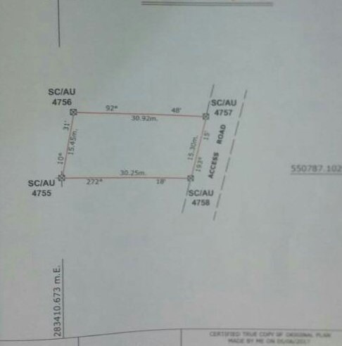
A survey plan defines the legal boundary of a piece of land. Prospective land buyers will like to know where the land of interest starts and ends. A survey plan gives such a description at a glance.
Viewing a survey plan, you can see at a glance, the size, shape, location, ownership, coordinates, etc of a piece of land. One of the most vital things in a survey plan is the coordinates of the land as it is unique to it. That is, you can’t find 2 different plots of land with the same coordinates. So a survey plan with the wrong coordinates is a catastrophe.
As much as possible, the survey plan describes the nearest Bus Stop, streets, junction, village to the plot of land. The details of the owner lie above it. And of course, it tells the number of square meters of the land.
Due to how detailed a survey plan is, it is the base document on which every other land document relies. The idea behind this is, “how do you talk about, prepare documents for or involve in a transaction on a piece of land whose full details you don’t know.
Now that you know the reasons or importance of a survey plan, let’s discuss a backdated survey plan.
Backdated Survey Plan
If you are reading this from the Diaspora, you should first note that the way land transactions are done in Nigeria might be slightly different from what holds in the advanced world.
Land sellers are supposed to have a survey plan for the land they intend selling but it’s not always so. This is especially true when it is owned by an individual or an omonile. They often lack this document because of the cost implication. Thus, leaving the buyer with the burden of preparing it when he intends to perfect his title. That’s one of the reasons you are constantly advised to buy land from real estate firms.
Going by the above scenario, the survey prepared by the buyer must show an earlier date than that of the deed of assignment and land receipt. A situation where it shows an older date means it is a backdated survey plan.
Why would someone go for a backdate survey plan?
It is for a reduced cost. It is far cheaper than the red copy. Backdated survey plan is not just about the date. It is about not lodging the survey at the Surveyor-General’s office. So the cost of lodgment is completely taken off.
By implication, the surveyor who did a backdated survey plan for you might gain more while he presented to you a copy as useless as the map of a dunghill as it can’t be used to perfect your title. This means that you will have to do another survey plan when you intend to perfect your C of O or other land documents.
A Flawless Survey Plan
From the previous section, you can deduce that a flawless or red copy survey plan is:
- One that has the right details about the land of interest. It should show the right size, coordinates, location, shape, name of the owner, the stamp of a registered surveyor, etc.
- One that is lodged at the office of the Surveyor-General. It is the lodging of the document at this office that makes it a legal document. Thus, making it a document that can be used to perfect other land titles or for defense on a land boundary dispute.
- One that is in the hands of the right person. You and I know that the wrong person can steal someone’s property document to sell the property.
- One that shows whether a piece of land is owned by the government or not.
If a survey plan lacks any of the aforementioned, it might land you in premium tears.
How To Chart Up A Survey Plan At The Surveyor-General’s Office
Not all plots of land are worth buying. Why some areas are set aside by the government for developmental purposes (like roads, bridges, stadiums, etc), others are for agricultural, residential, or mixed development purposes.
So before you buy a parcel of land you have to chart it up at the office of the Surveyor-General of your state:
- To be sure it meets the purpose for which you intend buying it.
- To be sure it is truly owned by the holder.
In Order To Chart Up A Survey Plan, You Have To:
- Get an Application Form for Land Information and Payment-Advise from the office of the Surveyor-General.
- Pay the required sum of money to the designated bank.
- Submit the receipt and teller collected from the bank as well as the Application Form for Land Information and the survey plan to the front desk of the Surveyor-General’s office.
A file will be opened for you at the front desk and sent to the office of the accountant to verify the receipt. It will then be forwarded to the Record Unit to trace the copy lodged with them.
It will be further forwarded to the Charting Room to reveal whether the property is free from Government acquisition or not and affirm the authenticity of ownership. Finally, the file goes back to the front desk and you pick it up there.
The process takes 1-2 months to complete.
But unfortunately, and as earlier stated, there is no way to figure out how to check survey plan online in Nigeria. All verification of registered survey plan must be channelled to the Surveyor General’s office.
Conclusion
Going by the information provided so far in this article, you are advised to stay clear of backdated survey plan because it is Penny wise, Pound foolish. What is worth doing is worth doing well.
Should a dispute occur on a property backed by such a survey plan, the property owner stands a big chance of losing it because:
- The government office (the Surveyor-General’s office) charged with the responsibility of keeping survey plan records doesn’t have a record of yours.
- The date shown on your survey plan (a survey plan showing your name as owner) is a date earlier than the date you bought the property as revealed by the deed of assignment/agreement and receipt. That will question your ownership of the property; how can you have a survey plan for a property even before you bought it?
The Nigeria Institute of Surveyors has criminalized the preparation of backdated survey plans. So any surveyor caught doing it will go to jail. This might affect you, the buyer.
Finally, if you want to invest in real estate, invest in peace of mind. Getting a red copy survey plan is one of the ways of achieving this.